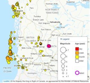
Earthquakes occur regularly in BC, however most do not have the right combination of magnitude and location to be noticeable or to significantly impact people. It is widely accepted, however, that an earthquake substantial enough to cause significant damage and destruction is inevitable in BC. A 2013 report by the Insurance Bureau of Canada indicated there is a 30% probability that a strong earthquake causing significant damage to infrastructure, including the cadastral fabric, will strike within 50 years.[1]
British Columbia’s Surveyor General (SG) is the Provincial authority charged with maintaining the integrity of the province’s cadastral survey system, which includes property boundaries and the survey monumentation used to define them. In the event of a significant earthquake, the SG has the mandate and expertise to guide the restoration of the cadastral fabric. From the SG’s perspective, an earthquake is considered significant if it displaces portions of the province’s cadastral fabric beyond the accuracy and precision standards prescribed for legal surveying and geo-referencing of those legal surveys.

Importance of the Cadastral Fabric in Disaster Recovery
After the necessary rescue and recovery efforts are made and cleanup is completed, individuals will turn to the re-building that will need to take place after a significant earthquake. A reliable cadastral fabric underpins this re-building effort, as it is necessary to know the extent of one’s property boundaries before proceeding with re-development. This means that a timely restoration of the cadastral fabric will be crucial to the province’s recovery after an earthquake. The professional land surveyors who operate in BC will be looking to the SG for appropriate guidance in correctly re-establishing legal boundaries after an earthquake, so they can do the work necessary to begin the province’s recovery.
New Survey Principles Needed after a Significant Earthquake
After a significant earthquake, it may not be possible to address the changes to the cadastral fabric with regular survey practices. For example, typical surveying practice in BC requires a disturbed survey monument to be re-set in its original location; this may not be possible or practical if an earthquake has shifted the land significantly so that infrastructure, houses, and other improvements have also moved, and no longer align with the original property boundaries. Instead, it may be in the public interest to accept the moved position of property boundaries after an earthquake so that conflicts with infrastructure and improvements are minimized.
The approach of recognizing boundaries in their moved position after an earthquake is called the “boundaries-moved principle.”
- This principle was used with success (and after much consideration) in New Zealand in the aftermath of their devastating Christchurch earthquakes in 2010.
- Enabling legislation is required to utilize the boundaries-moved principle in BC.
The boundaries-moved principle would not be applied automatically after a major earthquake; it would depend on the real-world outcomes of a particular earthquake. The decision to implement the boundaries-moved principle would need to be made after understanding the impacts of a particular earthquake.
Property Owners’ Role after a Significant Earthquake
After a significant earthquake, property owners in the affected area should consult with a land surveyor before rebuilding or developing property. Surveyors will have up-to-date knowledge on any change to survey guidance after an earthquake and will be able to accurately locate property boundaries so that property owners can begin to rebuild with confidence.
Earthquake Preparation
A significant earthquake will likely have a variety of impacts on the affected land: some areas may experience block shifts; some areas twists and distortions; and some areas liquefaction or land slippage. This means that the appropriate legal survey response may be varied and potentially unclear.
To prepare for a significant earthquake, the SG has created special survey practice guidelines that can be distributed to land surveyors after the earthquake occurs. These guidelines address many of the likely scenarios that will impact the cadastral fabric after a major earthquake, and how these should be dealt with by land surveyors. The guidelines use New Zealand’s response to their 2010 Christchurch earthquakes as a precedent, and are based on the boundaries-moved principle. The SG has consulted with a focus-group of BC land surveyors throughout the development of these guidelines to ensure there is stakeholder support.
The development of these guidelines for land surveyors is part of a comprehensive plan in preparation for a major earthquake. In addition to the guidelines, the plan includes actions to address after an earthquake, along with the appropriate stakeholders to engage with. It will be updated periodically to reflect legislative, survey practice, or organizational changes. In developing the plan, the SG has consulted with key stakeholders, including the Land Title Office, GeoBC, Ministry of Forests, and the Association of BC Land Surveyors. Consultation is continuing and the plan will be refined over time.
Through the preparatory actions of the SG both before an earthquake, and at definable time intervals afterwards, a process will be in place to efficiently repair the cadastral fabric and support certainty in the rebuilding process.
[1] Insurance Bureau of Canada. Study of Impact and the Insurance and Economic Cost of a Major Earthquake in British Columbia and Ontario/Québec. 2013. Retrieved from http://assets.ibc.ca/Documents/Studies/IBC-EQ-Study-Summary.pdf