Introduction
 In June 2021 Western North America experienced an unprecedented heat wave. As a result of this heatwave Lytton, BC experienced the highest temperature ever recorded in Canada[1] reaching 49.6 °C on June 29th. On June 30th, 2021, a wildfire began just south of the Village of Lytton which ultimately spread through the town and surrounding First Nation reserves. The fire destroyed 90% of the village structures including houses, businesses and public facilities such as the post office, ambulance station, health centre, RCMP detachment, Lytton Hotel, and the Lytton Village Office. This report is produced to document the efforts made by the Surveyor General after the wildfire to support the preservation of legal survey evidence during cleanup and rebuilding efforts. This report does not address re-establishment of boundaries within the impacted First Nation reserves because those lands are not surveyed under provincial legislation; staff at Natural Resources Canada supported the First Nation community in their boundary re-establishment efforts.
Background
The Surveyor General of British Columbia oversees the provincial land survey system and plays a vital role in the recording of spatial information in the land title register and Crown land registry by maintaining the quality and integrity of the cadastral fabric in the province.
 A land survey is represented by a survey plan, which is a scale-drawing identifying a parcel’s location relative to surrounding parcels and provides information on the parcel’s boundaries and size. The plan will show survey monuments and other evidence indicating the corners of the parcel and its boundaries. Land surveys of legal property boundaries are often referred to as ‘cadastral’, which comes from the French word referring to the register of lands. Land surveys as represented on survey plans make up the cadastral fabric of BC.
The land survey system and land title system work in tandem to establish secure ownership of a parcel and ownership of legal interests and rights to land in BC. Survey plans for titled land are deposited in the land title office and provide the spatial foundation for land title. In the land title system, the ownership of a parcel of land or an interest in a parcel is guaranteed upon registration in the land title register. However, the system does not guarantee the extent of the land contained in the parcel or the extent of an interest registered against a titled parcel. It is the land surveyor that is charged with accurately defining the geographic extent of parcels of land and interests in land.
The Surveyor General of BC decided to take a proactive approach to the preservation of the legal cadastre in the Village of Lytton after the 2021 wildfire. This approach was taken based on experience and lessons learned after the 2016 Fort McMurray[2] wildfires and various wildfires as experienced in California[3] in recent history.
Timeline
Following the devastating wildfire that destroyed much of the Village of Lytton on June 30, 2021, the Land Title and Survey Authority of British Columbia (LTSA) took immediate steps to support recovery efforts and ensure the preservation of the cadastral fabric. Early engagement by the Surveyor General with local land surveyors, and with provincial and municipal authorities, helped establish the need for legal survey work before site cleanup, recognizing the importance of maintaining property boundaries for future rebuilding. This led to collaboration with land surveyors, emergency management officials, and other stakeholders to plan and execute necessary surveys.
By August 2021, survey options had been discussed and it was decided that an initial survey should be conducted before site cleanup to tie and flag all existing survey monuments within the affected area, create a control network, and tie specific points for georeferencing drone imagery. Municipal funding challenges were addressed through a cost-sharing agreement, allowing the initial survey work to proceed.
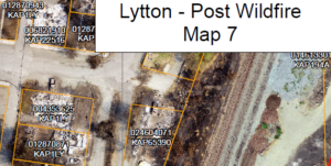
The LTSA provided land title documents and survey plans free of charge, in the public interest, to support the surveyors on the ground. The LTSA produced a cadastral overlay[4] of ParcelMap BC fabric with high resolution Orthophotos from GeoBC; this overlay was shared with the land surveyors working on site. Following delays due to an extreme weather event that significantly damaged highways across southern BC,the field work, for the initial scope of work, was completed in December 2021.
In early 2022, efforts continued with the submission of a posting plan to the Land Title Office, providing a crucial record of existing legal evidence before further site disturbance. Exton and Dodge Land Surveying produced materials to assist with educating the cleanup/construction crews to identify legal survey evidence and of the importance of preserving the evidence in the ground when possible. The framework for future survey phases was developed. High-resolution aerial imagery and terrain models were incorporated to refine the cadastral overlay, improving accuracy for reconstruction planning.
Through 2022 and 2023, the second survey phase was carried out as clean-up activities were completed, ensuring that key property corners were monumented. The LTSA facilitated access to updated imagery, survey data, and title searches to support rebuilding efforts. A second posting plan, completed in May 2023, provided a confirmed legal framework for property boundaries, ensuring accuracy for infrastructure redevelopment.
In 2024, a third phase of survey work was initiated to further reinforce the legal parcel fabric and ensure key block corners were in place for owners and future surveyors to rely on to re-establish legal boundaries. The final posting plan, registered in August 2024, confirmed the placement of key monuments and validated existing survey evidence, ensuring that the Village of Lytton had a strong cadastral foundation for reconstruction.
The coordinated response to the Lytton wildfire demonstrated the critical role of cadastral preservation in disaster recovery. By securing the legal framework of land ownership and property boundaries, the LTSA and its partners facilitated a smoother rebuilding process, providing a model for future disaster response efforts.
Options
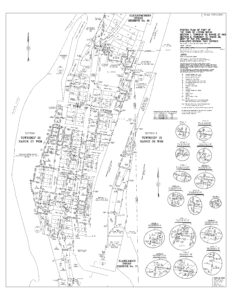
It was determined early on that the best type of survey and plan to prepare for this special circumstance was a Posting Plan under Section 68 of the Land Title Act. This would allow the Land Surveyor to easily put on record within the Land Title office their network of control points and the location of found and set evidence prior to any cleanup work proceeding. The Land Surveyor is able to deposit such a plan without the need to collect any approvals or consents of owners. As the survey covered approximately 167 parcels of land, owner consent would prove to be quite difficult and unnecessary when the Surveyor is simply tasked with documenting the state of the cadastre prior to cleanup.
There were a few other types of plans that could have been used in the aftermath of the wildfire in order to reconstruct the cadastral fabric. The options discussed included using the Municipal Replotting Act or a Special Survey under Part 23 of the Land Title Act. These types of Surveys are seldom used and have not been used in recent history within British Columbia. They also require extensive involvement of the Provincial Government and/or Municipal Government, and also require the costs to be apportioned between all affected owners, something that would be very difficult to administer and would be an unnecessary complication and burden to place on all the parties involved.
The potential disadvantage of using a Posting Plan to document re-set monuments, is that it expresses the opinion of the land surveyor as to the location of the property corners and the new posts are not original evidence. Therefore, land surveyors conducting future re-establishments of property boundaries will need to assess whether these new monuments should be accepted as the best evidence of the property corners. This was deemed an acceptable risk given that there were no known boundary issues in the community.
A survey under the Municipal Replotting Act would have been a suitable option if there was a desire to change the parcel structure in the community, for example, if it was deemed that re-building within certain areas of the community should no longer be allowed due to future disaster risk.
A Special Survey under Part 23 of the Land Title Act would have been a suitable option if there were known boundary issues in the community or a likelihood of future boundary disputes arising.
A Posting Plan, in fact three, completed at different stages of cleanup and reconstruction proved to be a good option. The plans registered have successfully achieved the desired outcome of setting up a local control network, documenting the status of legal survey posts and of setting the block corners of the Village up for an equitable distribution of the future expense of having a single property later surveyed when it comes time to rebuild and apply for a building permit.
Lessons Learned
The proactive engagement of the Surveyor General immediately post wildfire was key in educating the public, the Village and the Province of the importance of preserving the cadastral structure.
Having a surveyor/company that is familiar with the local situation is preferable to bringing in an external surveyor with no local experience. Knowing the history of the cadastral fabric and having previous experience working in the town is beneficial. Before cleanup occurs, the Surveyors should be consulted by recovery managers, engineers and planners as they can provide local knowledge of benefit to the recovery efforts.
Good communication between all parties is key to a successful end product. The land surveyor’s role in educating cleanup and construction staff of the value of cadastral survey monumentation is important and needs to occur ahead of activities before it is too late and destruction of monuments has already occurred.
Empathy and patience are very important when working in high stress situations post disaster. This type of work can take a toll mentally on all those involved, not just the residents, but the workers that come in after and see the destruction first hand. All workers, including Surveyors and their crews should be sensitive to the residents needs in an extraordinary situation like this.
It is critically important to the planning and timing of surveys that the Surveyors are informed of site activities and the recovery plan as a whole.
Conclusion
The 2021 wildfire in Lytton had an unprecedented impact on the community, essentially wiping out the majority of structures and services in the Village. The aftermath in Lytton was and continues to be very difficult for the community and residents. Three years post fire, the efforts of the Surveyor General’s office to preserve the cadastral fabric have been quite successful and the work completed by Exton & Dodge Land Surveying resulting in three posting plans has provided a good base for other land surveyors to work from to conduct further individual property surveys in an equitable way.
With climate change bringing with it more frequent extreme weather events such as wildfires and flooding, the need for cadastral preservation post disaster will continue to be something that the Surveyor General will pay close attention to. Each situation will be different, but certainly some of the experience gained in working through the 2021 Lytton Wildfire can be applied to future events of a similar nature.
_________
[1] Lytton, B.C. sets all-time Canadian heat record for third day in a row – Jon Azpiri (29 June 2021) – Global News.
[2] Official re-survey of Fort McMurray : effect of the 2016 wildfire on the survey fabric – Government of Alberta (15 July 2021)
[3] Monuments Going Up in Smoke – Carl C. De Baca, PS (12 August 2023) – The American Surveyor website
[4] See Appendix B – Example July 2021 – See PDF version.
_________
Surveyor General Report 2021 Lytton Fire (PDF) including posting plans, cadastral overlays and other images.
_________