LTSA extends their sincerest condolences to those land owners who have been affected by the devastating wildfires that have taken place in BC in the summer of 2023. We understand that the recovery process will be difficult and that there will be many competing priorities as the process unfolds.
As part of the disaster recovery process, LTSA’s Surveyor General would like to emphasize the importance of an accurate land survey.
Wildfires do not alter property boundary locations, but crucial survey evidence may have been lost, which can lead to increased survey costs and uncertainty in boundary locations. Some of the typical property boundary evidence, such as fences, hedges, and buildings may have been damaged or destroyed as a result of the fire. Survey evidence, such as the iron posts that mark property corners, is also at risk of being destroyed by the heavy machinery used in the recovery process.
The loss of boundary and survey evidence directly impacts land owners by making it more difficult to distinguish property extents, and may lead to confusion or misunderstanding on the true location of property boundaries. If left unresolved, unclear property boundaries can lead to issues such as property encroachment or new construction falling outside of bylaw setbacks.
This happened after the Fort McMurray wildfire disaster of 2016. In the recovery period, much survey evidence was destroyed making it difficult to ascertain the extent of property boundaries. Some land owners were granted building permits without conducting proper legal surveys and were later found to be encroaching or otherwise not meeting municipal setbacks.
To mitigate survey issues, the Surveyor General will be engaging with local land surveyors as well as local government to support an efficient, consistent survey response to the 2023 wildfires. The Surveyor General is recommending that local governments require a new legal survey as part of the development permitting process for properties impacted by the wildfire. Many local governments already require this as part of their regular development permitting process. Having a survey completed before redevelopment occurs will be crucial to ensuring misunderstandings and conflicts between property boundaries are minimized.
The Surveyor General has also made local governments aware of options for larger-scale surveys of affected areas. Larger-scale surveys that are started before land clearing can be used to flag existing survey evidence so that it is not destroyed in the reconstruction effort. These surveys can be beneficial to land owners by preserving survey evidence and ensuring that individual property boundaries can be referenced to recently verified survey evidence. This method was used after the 2021 Lytton wildfire and succeeded in preserving important survey evidence and in providing a common framework for other surveys to be undertaken.
Larger-scale surveys don’t make sense in every scenario and your local government will make a decision on initiating one depending on the specifics of the disaster recovery, your local government’s plans, and available funding.
It is also important for land owners to take their own initiative in minimizing the extent of damage to survey evidence that could take place during land clearing and other redevelopment activities on their property. The best course of action is to engage with a land surveyor early in the process. They may suggest coming to your property to inspect and flag any survey evidence that can be found before clearing, or other activities take place.
The Association of BC Land Surveyors provides background information on different types of survey monuments that may be present on your property.
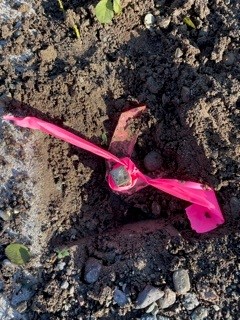
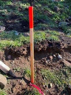
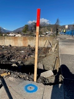
The below images show protection of survey evidence that took place during the Lytton wildfire recovery.

LTSA supports property owners through the difficult process of disaster recovery. The Surveyor General is actively working with land surveyors and local governments to help ensure that when property owners are ready to start redevelopment, the survey system is in a state to support the work that needs to be done.