Records Storage and Property History
Digitized records help expand access and preserve artifact integrity
Vault Records Inventory
In early 2005, LTSA committed to undertake a detailed inventory of the historic records in LTSA’s custody. By the end of the inventory process, more than 3,300 entries had been reviewed and recorded. The historic records inventory database is designed to produce reports that comply with national archival standards.
Each entry represents either an individual bound volume or a sub-series of documents or plans. Each volume or sub-series inventoried has been labelled with its unique inventory number.
The inventory of the paper format historic records of the seven original Land Title Offices and the Surveyor General is essentially complete. An overview of progress as of March 2013 provides the outside date range and the physical extent of the main land title record series captured in the inventory, as well as an inventory description for each.
Inventory updates continue to occur on an ongoing basis.
Storage of Records
- LTSA’s New Westminster vault houses historic records from the Vancouver and New Westminster land title districts.
- LTSA’s Victoria vault houses Victoria, Kamloops, Nelson, Prince George, and Prince Rupert land title district historic records.
- LTSA’s Victoria and New Westminster vaults have been custom designed to store and conserve historical records, including fire and flood damage mitigation.
- DocuWare, the document management software LTSA uses to store digital historic records, is accessible by LTSA employees and those with direct access privileges, who have a DocuWare user account, from terminals in the LTSA’s offices.
- LTSA is in the process of digitizing approximately 48,000 reels of microfilm. There are approximately 7,000+ reels associated with the Kamloops and Nelson land title districts which were digitized and accessible through DocuWare prior to the duplicate microfilm reels being relocated to Victoria in October 2021.
Records Inventory
The table below provides an overview of the date range and physical extent of the historic land title records of the seven original land title offices. Please note:
- It does not identify gaps in records holdings, missing volumes, or other anomalies that are explained in the inventory database that will be made available on this website when completed. For the purpose of this overview, partial volumes are treated as whole volumes.
- To date, the historic records inventory has focused on land title records in paper format. Consequently, records that exist only in microform or digital format are not included in this overview. Some of the documents coded as “None Found” may in fact exist on microfilm.
- “Ongoing” indicates that the record series was still being created in 2008. The plus (+) sign following a quantity of plans indicates that the number is approximate because the series is ongoing.
| Victoria | New Westminster | Vancouver | Prince Rupert | Prince George | Kamloops | Nelson | |
| Inclusive Years | 1860 ongoing | 1885 ongoing | 1891-1990 | 1909-2002 | 1966-2002 | 1893 ongoing | 1901-1997 |
| Record Series Title | |||||||
| Absolute Fees Parcels Book | 12 volumes, 1861-1907 |
10 volumes, 1871-1915 |
8 volumes, 1871-1905 |
1 volume, 1874-1906 |
None Found | 6 volumes, 1870-1907 |
5 volumes, 1881-1906 |
| Bylaw Plans | 1012 plans, 1919-1980 |
None Found | None Found | None Found | None Found | None Found | None Found |
| Certificates of Indefeasible Title | 5 volumes, 1866-1905 |
3 volumes, 1884-1954 |
1 volume, 1905-1913 |
None Found | None Found | 1 tank, 1910-1912 |
5 dockets, 1914-1923 |
| Charge Parcels Book | 8 volumes, 1861-1906 |
6 volumes, 1870-1905 |
7 volumes, 1871-1905. |
1 volume, 1870-1905 |
None Found | 4 volumes, 1870-1906 |
2 volumes, 1886-1906 |
| Church Property Plans | 31 plans, 1924-1951 |
None Found | None Found | None Found | None Found | None Found | None Found |
| Conveyances | 6 volumes, 1861-1870 |
3 volumes, 1862-1870 |
None Found | None Found | None Found | 9 volumes, 1862-1870 |
1 volume, 1867 only |
| Crown Grant Documents | 4 tanks of documents, 1920-1980 |
75 tanks of documents, 1892 ongoing |
43 tanks and 42 files of documents, 1872-2001 |
70 tanks of documents, 1895-2000 |
156 tanks of documents, 1896-2002 |
171 tanks of documents, 1893 ongoing |
120 tanks, 1896-1997 |
| Deeds Deposited | 497 tanks of documents; 1860-1979 |
1 tank; 1880-1919 |
None Found | None Found | None Found | None Found | 2 tanks, 1892-1918 |
| Documents Deposited | None Found | None Found | None Found | None Found | None Found | None Found | None Found |
| Documents Filed | 20 tanks of documents, 1862-1971 |
64 drawers plus 10 records storage boxes of documents, 1920-1959 |
None Found | 2 tanks of documents, ca. 1900-1971 |
None Found | None Found | 2 tanks of documents, 1921-1966 |
| Documents Filed Plans | 970 plans, 1929-1967 |
49 tanks, 1929-1987 |
187 tanks, 1887-1991 |
12 tanks of plans, 1912-1971 |
None Found | ca. 1080 plans, 1899-1966 |
11 tanks of plans, ????-1966 |
| General Plan Series | 79430+ plans, 1861 ongoing |
170300+ plans, 1878 ongoing |
22800 plans, 1882-1991 |
74000 plans, 1915-1997 |
ca. 35500 plans, 1909-2002 | 25 tanks of plans, 39000 plans, also those in a blended series, 1914 ongoing | None Found |
| Highway Plans | Filed in Right-of-Way Plan series | None Found | 182 plans, 1953-1978; effective 1979, filed in Explanatory & Reference Plan series | Inventory in Progress | 250 plans, plus those in Running Number Series, 1948-1994 |
954 plans, 1947-1967; plus series plans in a blended series, 1967-1985 |
374 plans, 1931-1975 |
| Indian Reserve Plans | 79 plans, 1876-1934 |
None Found | 1 plan, 1916 |
None Found | 2 plans, ????-1964 |
None Found | None Found |
| Key Plans | 1351 plans, 1914-1946 |
1675 plans, ????-1981 |
4 map books and 324 plans, 1914-1985 |
None Found | None Found | 1 volume, ????-???? |
154 plans and 1 volume, 1914-1953 |
| Official Survey Plans | 796 plans, 1909-1980 |
None Found | None Found | None Found | None Found | None Found | None Found |
| Posting Plans | 4370 plans, 1965-1980 |
930 plans, 1991 only; effective 1992, filed in General Plan Series | 122 tanks, 1937-1991 |
None Found | None Found | Part of approx. 2800 plans, 1966-1987, after which filed in General Plan Series | None Found |
| Railway and Foreshore Plans | None Found | None Found | 19954 plans, 1907-1990 |
None Found | None Found | None Found | None Found |
| Railway Plans | None Found | None Found | None Found | ca. 73 plans, 1903-1960 |
None Found | ca. 300 plans, 1913-1955 |
None Found |
| Record of Agreements and Miscellaneous Instruments | 3 volumes, 1870-1921 |
None Found | 4 volumes, 1884-1932 |
None Found | None Found | 2 volumes, 1870-1893 |
1 volume, 1888-1900 |
| Record of Conveyances | 2 volumes, 1870-1921 |
2 volumes, 1870-1920 |
2 volumes, 1871-1907 |
None Found | None Found | 7 volumes, 1862-1910 |
2 volumes, 1877-1920 |
| Record of Mortgages | 2 volumes, 1870-1919 |
None Found | None Found | None Found | None Found | 1 volume, 1870-1893 |
2 volumes, 1867-1899 |
| Reference and Explanatory Plans | None Found | ca. 17460 plans, 1911-1960 |
ca. 20650 plans, 1911-1991 |
None Found | None Found | None Found | None Found |
| Reference Plans | 2089 plans, 1936-1980 |
None Found | None Found | None Found | None Found | ca. 1760 plans as part of a blended series, 1967-1985 |
None Found |
| Register of Absolute Fees | 38 volumes, 1861-2003 |
55 volumes, 1871-2001 |
32 volumes, 1870-1919 |
3 volumes, 1874-1990 |
1 volume, 1894-1950 |
19 volumes, 1870-1991 | 19 volumes, 1881-2006 |
| Register of Charges | 34 volumes, 1861-2000 |
25 volumes, 1870-2004 |
45 volumes, 1871-1998 |
3 volumes, 1870-1990 |
1 volume, 1912 only |
11 volumes, 1870-1991 |
8 volumes, 1886-2006 |
| Register of Indefeasible Fees | 11 volumes, 1905-1914 |
15 volumes, 1905-1915 |
19 volumes, 1905-1917 |
6 volumes, 1905-1915 |
1 volume, 1906-1913 |
7 volumes, 1905-1920 |
3 volumes, 1905-1922 |
| Register of Mortgages | 2 volumes, 1861-1870 |
None Found | None Found | None Found | None Found | 7 volumes, 1861-1920 |
None Found |
| Right-of-Way and Easement Plans | None Found | None Found | None Found | None Found | ca. 600 plans, 1914-1966 |
part of blended series, 1914-1985 | None Found |
| Right-of-Way Plans | 3480 plans, 1913-1980 |
6 plans, dates not yet determined | None Found | None Found | 850 plans, 1916-1966 |
ca. 3260 plans, 1916-1985 |
642 plans, 1938-1975 |
| Satisfaction Book | 7 volumes, 1861-1911 |
None Found | 10 volumes, 1876-1911 |
None Found | None Found | 5 volumes, 1878-1912 |
5 volumes, 1888-1912 |
| Strata Plans | 5846+ plans, 1968 ongoing |
10111+ plans, 1968 ongoing |
2893 plans, 1968-1991 |
100+ plans, 1970-2001 |
356 plans, 1974-2002 |
318+ plans, 1970 ongoing |
231 plans, 1974-1997 |
| Subdivision Plans | None Found | None Found | None Found | 3 plans, 1914 only |
None Found | ca. 36000 plans, 1893-1985 |
ca. 20850 plans, 1885-1997 |
| Supplemental Charge Book | 1 volume, 1861-1870 |
None Found | None Found | None Found | None Found | None Found | None Found |
| Supplemental Charges Parcels Book | 1 volume, 1861-1870 |
None Found | None Found | None Found | None Found | None Found | None Found |
Property History
The table below provides a sense of the information contained in the variety of historic land title records in which land transactions were documented.
The documents from 1870 to 1894 included here reveal only part of the story of the land amassed by Henry Elliott and transferred in 1894 to his wife Ellen Elliott.
For the present purpose, it would be too complicated to include the earlier documents relating to the whole of the property to which Mrs. Elliott was listed as the absolute fee owner from 14 February 1894. The documents from 1906 to 1912 relate specifically to Lot 15, Block XXXVI, City of New Westminster, and show the history of transactions relating to Lots 1, 2, 3, and 4 on Tenth Street, between Queens Avenue and Auckland Street, during those years.
For illustrative purposes only, digital scans have been cropped to exclude non-relevant transactions and pasted together to present each transaction as a single image where a transaction spans two pages.
Please note that this is not a definitive title search, rather a representation to show the inter-relationships between record series.
| Records Source | Date | Brief Description of Documented Transactions | Image |
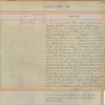
| W, Conveyance Book vol. 2, folios 181 and 182, no. 2263 | 30 May 1870 | On 30 May 1870, the Indenture from Henry Bruce to Henry Elliott, dated 24 May 1870 and conveying certain lands in the District of New Westminster, was deposited for registration at the Land Registry Office. That document explains that Henry Elliott had paid Henry Bruce $150 to purchase 150 acres of land. | 1 |
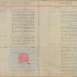
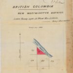
| NW, Crown Grant 15465F | 3 November 1874 | Henry Elliott acquired a further 44 acres in New Westminster District by Crown grant from the provincial Crown dated 3 November 1874. He paid $49.50 for the surface rights, with gold and silver ore explicitly reserved to the Crown. The Crown Grant originally numbered 1463 was signed by Lieutenant-Governor Joseph W. Trutch in the top right-hand corner, by Chief Commissioner of Lands and Works Robert Beaven, beneath the coat of arms, and by Provincial Secretary John Ash at the bottom.
The sketch attached to the Crown grant highlights in red the parcel conveyed to Henry Elliott, showing that Section Twenty-eight (28), Block Five (5) North, Range Four (IV) West, New Westminster District, is along the North Arm of the Fraser River. Again, the sketch is signed Robert Beaven, CCLW.
The annotation on the reverse of the Crown grant shows that it was deposited at the Land Registry Office and registered on 14 February 1894 in Absolute Fees Book, volume 19, folio 155 as part of absolute fee 480F. The Crown Grant was just one of the long list of instruments submitted that continued over the page. |
2, 3, 4, 5, 6 |
| W, Conveyance Book vol. 2, folios 181 and 182, no. 2263 | 30 May 1870 | On 30 May 1870, the Indenture from Henry Bruce to Henry Elliott, dated 24 May 1870 and conveying certain lands in the District of New Westminster, was deposited for registration at the Land Registry Office. That document explains that Henry Elliott had paid Henry Bruce $150 to purchase 150 acres of land. | 1 |
| NW, Crown Grant 15465F | 3 November 1874 | Henry Elliott acquired a further 44 acres in New Westminster District by Crown grant from the provincial Crown dated 3 November 1874. He paid $49.50 for the surface rights, with gold and silver ore explicitly reserved to the Crown. The Crown Grant originally numbered 1463 was signed by Lieutenant-Governor Joseph W. Trutch in the top right-hand corner, by Chief Commissioner of Lands and Works Robert Beaven, beneath the coat of arms, and by Provincial Secretary John Ash at the bottom.
The sketch attached to the Crown grant highlights in red the parcel conveyed to Henry Elliott, showing that Section Twenty-eight (28), Block Five (5) North, Range Four (IV) West, New Westminster District, is along the North Arm of the Fraser River. Again, the sketch is signed Robert Beaven, CCLW. The annotation on the reverse of the Crown grant shows that it was deposited at the Land Registry Office and registered on 14 February 1894 in Absolute Fees Book, volume 19, folio 155 as part of absolute fee 480F. The Crown Grant was just one of the long list of instruments submitted that continued over the page. |
2, 3,4 5, 6 |
| NW, AFB vol. 19, folios 155 and 157, no. 480F
NW, AFPB, vol. 10, folio 634, no. 480F |
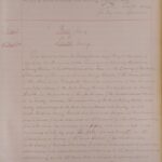
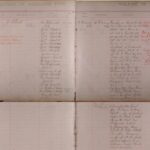
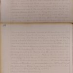
14 February 1894 | On 14 February 1894, at New Westminster Land Registry Office, Ellen Elliott was registered as the absolute fee owner of a whole list of property within the City of New Westminster, including Lot 15, Block XXXVI, referred to below in later documents. The Parcels Book column indicates that a description of the property was entered in the Absolute Fees Parcels Book. At the bottom of the List of Instruments column, we learn that Ellen Elliott had received the lands described in the Parcels (Short Description) column from her husband Henry Elliott by conveyance in fee dated 10 February 1894. | 7,8 |
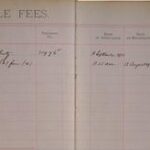
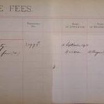
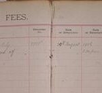
| NW, IFB vol. 1, folio 104, no. 8999F | 29 August 1906 | On 29 August 1906, at New Westminster Land Registry Office, Elizabeth Hembrough was registered as the indefeasible fee owner of Lots 1 and 2 by conveyance dated 20 August 1906 from Charles Stephen Vaughan Branch. | 9 |
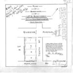
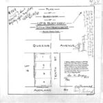
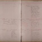
| NW, plan 969 | 1 May 1907 | On 1 May 1907, a plan of the subdivision of Lot 15, Block XXXVI, City of New Westminster, was deposited in the New Westminster Land Registry Office. The plan, showing Lots 1, 2, 3, and 4 on Tenth Street between Queens Avenue and Auckland Street, was certified and signed by British Columbia Land Surveyor William Nelson Draper. New Westminster Mayor W.H. Keary signed the plan to certify that conditions 1, 2, and 3 of section 68 of the Land Registry Act had been complied with. Among the other annotations on the plan is the signature of Mrs. E. Hembrough. | 10 |
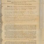
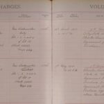
| NW, CB vol. 16, folio 101, no. 7699C | 2 November 1907 | On 2 November 1907, at New Westminster Land Registry Office, James O’Halloran was registered as the owner of a charge against Lot 2 (only) by mortgage in fee 30 October 1907 from Elizabeth Hembrough. The information annotated within the red-ink rubber stamp indicates that the charge was cancelled on 24 March 1911 and entered in the New Westminster Satisfaction Book, vol. 3, folio 455 (that volume no longer exists). | 11 |
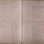
| NW, CB vol. 19, folio 114, no. 13460F | 26 April 1910 | On 26 April 1910, at New Westminster Land Registry Office, Lewis Charles and Joseph Reid were registered as the owners of a charge against Lots 1, 2, 3 and 4 by agreement for sale and purchase dated 7 March 1910 from Elizabeth Hembrough. | 12 |
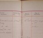
| NW, CB vol. 19, folio 114, no. 13598F | 7 May 1910 | On 7 May 1910, at New Westminster Land Registry Office, David K. Newell was registered as the owner of a charge against Lots 1, 2, 3 and 4 by agreement for sale and purchase dated 11 April 1910 from Charles Lewis and Joseph Reid, pursuant to the agreement for sale and purchase dated 7 March 1910 from Elizabeth Hembrough to Charles Lewis and Joseph Reid. | 13 |
| NW, IFB vol. 8, folio 5, no. 31975F | 12 August 1912 | On 12 August 1912, at New Westminster Land Registry Office, Lewis Charles and Joseph Reid were registered as the indefeasible fee owners of Lots 1, 2, 3 and 4 by conveyance dated 12 September 1911 from Elizabeth Hembrough. | 14 |
| NW, IFB vol. 8, folio 6, no. 31976F | 13 August 1912 | On 13 August 1912, at New Westminster Land Registry Office, David K. Newell was registered as the indefeasible fee owner of Lots 1, 2, 3 and 4 by conveyance dated 12 September 1911 from Joseph Reid and Charles Lewis (by his attorney Joseph Reid) . | 15 |
Sample Property History - Image Gallery
In the section below, you can see a set of historic records examples. In these photos, a digital scan of a typical page for seven different record series shows the type of information each contains.


Historic Record Samples
This selection of document images was made on the basis of a typical search to trace the ownership of a particular piece of land and includes the major record series.