The River has Moved. What do I do?
The River has Moved. What do I do?
By Jeff Beddoes BCLS (N/P), (CLS ret.)
Statutory right of way plans that cross both private land and Crown owned bodies of water where natural boundaries do not agree (or, The river has moved. What do I do?)
The following document was drafted by Jeff Beddoes BCLS (N/P), (CLS ret.), with input from Land Title staff, in developing a procedure to address the situation where a statutory right of way plan is being surveyed across a titled parcel and across a Crown-owned creek which runs through the parcel, where the present location of the creek materially differs from its location according to the plan or document upon which title is based. Rule 5-2 of the Survey and Plan Rules require that such a discrepancy is dealt with.
Although the procedure assumes a situation where the creek has actually changed location through lawful accretive and erosive forces; the same procedure would be available in a “natural boundary adjustment” scenario, where the creek remains where it always has been but was incorrectly depicted on the title-defining plan or document. Of course if the water course has moved suddenly, then the title boundaries likely have not shifted location and the guidance contained in this article is likely not applicable.
This is being published in the Link to provide guidance to members on how they may be able to deal with such a situation. Members are welcome to contact the Practice Advisory Department or Surveyor General staff, to discuss their particular project.
Respectfully submitted,
Practice Advisory Department and Surveyor General staff
The following scenario describes both the problem being addressed as well as a solution.
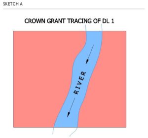
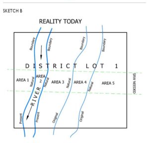
District Lot 1 was granted by the Province in 1950 to Mr. Smith. The tracing attached to the Crown grant shows the area of DL 1 that was granted in a red wash, and a river which was not granted in a blue wash, as shown on Sketch A. Since 1950, the river has moved slowly to the location shown on the Sketch B. And now, a utility company has strung a new power line across DL 1 as shown on the sketch and wants SRW tenure. In accordance with common law, today Mr. Smith continues to own all of DL 1 above the natural boundary and the Crown continues to own the river, even though the location of the river within DL 1 has changed considerably.
The change in the location of the river creates a conflict with the land title records. The land title office is in the position where they can only accept an SRW charge granted by Mr. Smith over the land that their records show he owns. In other words, without some extra work (described below), the land title office can only register an SRW charge for the titled portion of DL 1 as that titled portion was defined on the 1950 Crown grant. Referring to the numbered areas on the sketch above, the land title office can only accept an SRW charge granted by Mr. Smith over Areas 1, 2, 3 and 5.
Further, the land title office can only register an SRW charge from the Crown over what their records indicate to be Crown land, being Area 4 on the attached sketch. This of course is problematic because Mr. Smith does not own Area 2 and does own Area 4, and the Crown does not own Area 4, but rather owns Area 2. Section 118 of the Land Title Act can offer some remedy to this conundrum, as it provides a simple mechanism to take lawful accretion, (in the example, Area 4), into Mr. Smith’s title. Unfortunately section 118 does not provide a tool through which ownership of the river, (Area 2), can be taken off of Mr. Smith’s title and returned to the Crown.
The following is a solution to this problem.
Procedure
- A reference plan is prepared pursuant to section 108(1) of the Land Title Act. The plan returns to the Crown in right of the Province the submerged lands (Area 2). The heavy outline on this plan encompasses only the land currently below the natural boundary within the desired SRW area. No other portions of the parent parcel are dealt with on the plan. This plan will require owner and charge holder consent and the approval of the Approving Officer. Upon registration of this plan the submerged area becomes Crown land and Mr. Smith’s title shows this exception.
- A statutory right of way plan is prepared which includes a certificate pursuant to section 118 of the Land Title Act. The land within the heavy outline on this plan includes Area 1, Area 3, Area 5 and Area 4. Area 2 is depicted in the scenery as Crown land by virtue of the preceding plan. The s.118 certificate serves to convey Area 4, being lawful accretion, to Mr. Smith. This statutory right of way plan is registered in the land title office. Mr. Smith can now grant a statutory right of way over Areas 1, 3, 4 and 5.
- A statutory right of way plan is prepared over the untitled Crown land being Area 2. This statutory right of way plan is registered in the land title office. The Crown can now grant a statutory right of way over Area 2. Upon receipt of the grant of statutory right of way, (Form C), the land title office will raise a title to Area 2 pursuant to section 24 of the Land Title Act Regulations and lodge the SRW charge against this title. Separate statutory right of way instruments (in other words two SRW plans and two SRW charge documents) must be prepared in this scenario, one set for the private land and one set for the Crown land.