Surveyor General’s Report: ABCLS AGM 2026
Surveyor General Report to ABCLS, March 2026
By Cristin Schlossberger, BCLS
It’s a pleasure to provide an update on the activities of the Land Title and Survey Authority over the past year.
I want to begin by acknowledging the important role that BC land surveyors play in maintaining the integrity of our land title and survey systems. LTSA relies on your professionalism and expertise.
I’ll begin with organizational and operational updates, and then move into several key initiatives and projects that are underway or coming soon.
Organization Updates
In 2025 we celebrated the 20th anniversary of the LTSA. Every 5 years LTSA and the Province undertake a formal Operating Agreement review to ensure that both parties are meeting their obligations. That review has just been completed, and the consultant’s report will be made available publicly by both parties. The results of the report are positive and confirms that both parties are fully meeting their responsibilities.
I’d like to thank Bronwyn Denton and BJ Houghton for their continued service as ABCLS-nominated members of the LTSA Board of Directors. Their contributions are greatly valued.
Despite ongoing uncertainty in the property market, LTSA remains financially stable and operationally strong. We continue to execute on the strategic priorities set out in our strategic and business plans and remain focused on improvements that serve the public interest and strengthen the system over the long term.
One of these initiatives is our application platform modernization, which is a 3 year program delivering incrementally on four main objectives, including: updating the technology for the land title register, creating a single access point, or portal, for all LTSA customers, aligning and upgrading our geospatial capabilities, and improving data analytics capabilities.
Separately, one of our most significant initiatives was recently approved by the LTSA Board, it is a multi-year investment in the digitization of vault records. Over the next five years, approximately $26 million will be invested in accelerating the conservation, processing, and digitization of our vault records.
The goal, in that 5 year timeframe, is to process and index 100% of the vault records, and to digitize approximately 70% of the records, by volume, focusing on the highest priority records. There are about a million items for digitization, with varying complexity. Where records contain colour, they will be scanned in colour. We are also considering options to enhance access to the records.
The Victoria and New Westminster vaults have been optimized to allow contractors to efficiently work on the conservation, processing and digitization of the records. Scan on demand services will be unaffected while this work is underway.
One of the first priorities is the indexing and scanning of the remaining field books. Of approximately 108,000 field books in our custody, roughly 103,000 remain to be digitized. This represents a significant volume of historic survey information, and making these records digitally accessible will meaningfully improve long-term access and preservation.
Land Title Update
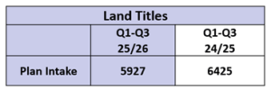
In the first three quarters of the current fiscal year, plan volumes have remained relatively low, reflecting broader market conditions.
Plan submissions to the Land Title Office decreased by 8% in the first 3 quarters of this fiscal year, compared to the same time period last year. The annual average turnaround time for Land Title Act instruments is currently at 2.9 days.
Land title transaction volumes are expected to increase by approximately 4% in the next fiscal, as we’re anticipating a modest recovery in real estate volumes.
As of September 2025, the LTO began automating the examination of Statutory Right of Way plans submitted without accompanying documents. These plans are now processed using the same system as Posting Plans, typically resulting in finalization 48 hours after submission. Plan alterations can only be made while the plan is pending, or if a notice declining to register is issued.
In October, the Survey Plan Certification and Survey Plan Submission to Surveyor General forms were updated to reflect revised Surveyor Statements. The revised statements confirm that the BCLS personally superintended the survey represented by the plan and that the survey and plan are correct and comply with the Survey and Plan Rules and all applicable statutes. There is no longer a specific reference to being “present at” the survey.
SG Operations Update
I would like to thank our staff in Operations, including Deputy Surveyors General Dave Swaile, Katie Hannah, and Chris Sakundiak, for their continued leadership and diligence. We continue to meet our target turnaround times for processing applications, plans and Crown grants.
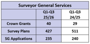
For the first 3 quarters of this fiscal year, Crown grant volumes increased by 38%. This builds on an 18% increase the previous year. The majority of these grants are related to First Nation agreements.
Plan submissions to the Surveyor General have continued the decreasing trend we saw last year, with a 16% decrease. The volume of applications remains relatively stable, with only a 2% decrease.
Operations Policy and Boundary Commission
The volume of work supporting surveys for First Nations agreements continues to be high and remains a significant priority. We expect this volume to grow in the coming years with several treaties in the process of ratification.
Recently we provided guidance regarding the process to survey existing highways through untitled Crown land where the highway was established by gazette notice and no legal survey of the highway has been completed. This guidance has been incorporated into Direction to Land Surveyors #15.
The Survey and Plan Rules were updated to clarify the circumstances in which the Surveyor General may issue specific instructions that differ from the Rules. Direction to Land Surveyors #16 and Circular Letter 475 were updated accordingly.
Boundary Commission:
This last year the Boundary Commission undertook one inspection contract consisting of surveys in three passes along the boundary; Palliser, White Man and Assiniboine. A total of 26 monuments were inspected and catalogued.
For the upcoming survey season, a restoration survey is being contracted for 33 monuments along the 120th meridian.
I also note that in 2025, Jean Gagnon retired as Surveyor General of Canada Lands and Martin Gringas has been appointed as his successor as Canada’s representative on the Boundary Commission.

Disaster Recovery
In Spring 2025, the Province sought feedback on the Post-Earthquake Boundary Restoration Plan and is considering the input received. Thank you to the BC Land Surveyors who provided thoughtful and constructive feedback.
Over the past year, I’ve presented on BC’s disaster recovery initiatives to land surveyors in Saskatchewan and Nova Scotia, as well at the Canadian Council on Geomatics GeoResilience Forum. These presentations have been well received, and other jurisdictions are looking to implement lessons learned from BC’s work.
Thank you to Peter Haas and Tobin Pope for all your work on these and other initiatives.
PMBC Operations Update:
The migration to ArcGIS Pro platform in Fall 2024 presented some challenges for the PMBC team. Posting plans were temporarily placed in a backlog while staff concentrated on integration of datasets that altered the parcel fabric.
In early 2025 the team resolved those challenges and brought on additional resources. We are now back under our two-day turn-around target, and the team has resumed work on additional priorities.
The internal working fabric infrastructure has been upgraded, and we will soon introduce upgrades to the external viewer. This new map viewer will run in parallel with the current ParcelMap search services for a period before the current version is retired. Collectively, these upgrades significantly strengthen our geospatial infrastructure and better position us for future initiatives.
Projects
Datum modernization
We continue to support GeoBC in the transition to modern vertical and horizontal datums. Fieldwork to improve the accuracy of physical control monument coordinates is now complete and GeoBC anticipates adopting the new vertical and horizontal datums in 2030.
After 30 years of service, the MASCOT database is being replaced by GeoNetBC. As of March 30, 2026, GeoNetBC will become the official source of survey control coordinates. MASCOT will continue to function for a limited time, but is no longer being updated. GeoNetBC will need to be used for land surveying purposes.
We will continue working collaboratively to ensure that we are aligned with GeoBC and that these transitions are well coordinated with the land surveying profession.
Verified Transaction
The aim of Verified Transaction is to modernize identity verification for homeowners, professionals and others involved in real estate transactions for greater security. Also, to improve digital connectivity across the real estate transaction to make the whole system stronger and more efficient.
LTSA has been piloting the use of the lawyer credential in place of Juricert and we have received positive feedback. The use of the credential, issued by the Law Society, will be available to all lawyers in the coming months. The next step is expansion of the professional credential capability to BC Notaries. We are also in discussions with the ABCLS about the potential for a land surveyor credential.
A land surveyor credential could enhance security while giving the ABCLS direct control over issuance and revoking credentials. We look forward to continuing these conversations.
Using the same technology infrastructure, BC Property Connect is a new service that allows landowners to create a secure digital connection to their property. This enables title change notifications, and provides easy access to order records and complete simple tasks, such as updating an address.
There are future opportunities with this service that are being investigated. An early use case is being piloted by the City of Vancouver to verify short-term rental permit applicants are the registered owners of the property. BC Property Connect is currently available to pilot users and will be rolled out to the public soon.
LTSA Account Modernization
LTSA account web pages have been progressively updated to improve workflow efficiency, navigation, and mobile accessibility.
Enhancements have also been made to the Plan Preview feature within ParcelMap Search Services to improve usability, reduce unnecessary Scan on Demand requests, and strengthen data protection. Where colour image exists, plan previews are now displayed in colour.
Plan previews remain for preliminary research only. Plans must be purchased for business purposes and should never be used for surveys or statutory applications. The updated plan preview functionality will be incorporated into LTSA account in the future.
SurveyHub
Adoption of SurveyHub continues to grow, with 76% of plan submissions to the Land Title Office now being assembled through the platform. All Surveyor General submissions are currently assembled in SurveyHub.
Beginning in Spring 2026, SurveyHub will become mandatory for all LTO submissions and all new dataset submissions. The separate survey plan dataset submission functionality will be retiring in a phased approach.
We recognize that mandatory adoption represents change, and we are committed to ensuring the transition is smooth and well supported. I encourage you to use SurveyHub as early as possible and reach out if you require support.
We are now shifting development focus to modernize the filing process, which will streamline the submission from SurveyHub to LTSA.
Thank you to the Land Surveyors Advisory Task Force and pilot participants who provided feedback throughout the planning and development process. SurveyHub is a result of collaborative effort.
Conclusion
In closing, LTSA remains stable, forward-looking, and focused on continuous improvement. We are investing in long-term preservation of records, modernizing our digital infrastructure, strengthening security, and maintaining strong service levels, all while supporting significant work related to First Nation agreements and broader public interest priorities.
We rely on a strong and engaged land survey profession and I look forward to continuing to work together to ensure the integrity of the land title and survey system.