Integrated Survey Area Program
Contents
The Integrated Survey Area Program establishes an infrastructure of coordinate control monuments within participating municipalities. The network of coordinate control monuments provides a standard vertical and horizontal reference system that supports mapping, engineering, surveying and other works.
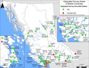
A copy of the above map can be downloaded here.
There are forty-nine municipalities in BC that are official Integrated Survey Areas (ISAs) consisting of a framework of over 20,000 coordinate control monuments providing the foundation for passive georeferencing activities.
ISA passive networks of control points work in conjunction with the British Columbia Active Control System, providing an enhanced georeferencing environment with multiple compatible sources.
Please note:
- Land surveyors operating within an official integrated survey area are required to tie legal surveys to coordinate control monuments. This requirement supports the ongoing georeferencing of the cadastral fabric.
- ParcelMap BC Search for Land Surveyors provides access to land cadastral information, including the official published Integrated Survey Area boundaries and locations and details of coordinate control monuments.
- Access the MASCOT homepage of the GeoBC Division of the Ministry of Land, Water and Resource Stewardship to obtain control monument sketches and detailed coordinate information and revision history.
- Both land surveyors and municipalities have a responsibility to update the condition of coordinate control monuments in an ISA. See Reporting Coordinate Control Monument Condition for more information.
ISA plans and listings
The official ISA boundaries are in digital form and may be viewed within ParcelMap BC for Land Surveyors, or as a ParcelMap BC guest user. The locations of coordinate control monuments are referenced from MASCOT, but can be viewed within ParcelMap BC for Land Surveyors.
Please note:
- The official ISA coordinate control listings are available by clicking on the appropriate ISA number below.
| ISA Number | ISA Name |
| 1 | Surrey |
| 2 | Dawson Creek |
| 3 | Nelson |
| 4 | Kelowna |
| 5 | Elkford (Annulled December 19, 2018 – see Circular Letter No. 480) |
| 6 | Granisle |
| 7 | Logan Lake (Annulled December 21, 2022 – see Circular Letter No. 488) |
| 8 | Mackenzie |
| 9 | Cranbrook |
| 10 | North Cowichan |
| 11 | Duncan (Annulled December 21, 2022 – see Circular Letter No. 488) |
| 12 | Penticton |
| 13 | Delta |
| 14 | Coquitlam |
| 16 | North Vancouver District |
| 17 | Victoria |
| 18 | Richmond |
| 19 | Vernon |
| 20 | Nanaimo |
| 21 | Central Saanich |
| 22 | North Saanich |
| 23 | Kamloops |
| 24 | Abbotsford |
| 25 | Burnaby |
| 26 | Powell River |
| 27 | Rossland (Annulled December 21, 2022 – see Circular Letter No. 488) |
| 28 | Campbell River |
| 29 | Sidney |
| 30 | Saanich |
| 31 | Vancouver |
| 32 | Parksville |
| 33 | Tumbler Ridge |
| 34 | Oak Bay |
| 35 | Port Moody |
| 36 | Maple Ridge |
| 37 | Port Alberni |
| 38 | Esquimalt |
| 39 | Prince George |
| 40 | Colwood |
| 41 | Langley Township |
| 42 | White Rock |
| 43 | Ladysmith |
| 44 | North Vancouver City |
| 45 | Langley City |
| 49 | New Westminster |
| 50 | Fort St. John |
| 51 | Langford |
| 52 | Gibsons |
| 54 | City of Williams Lake |
| 55 | Terrace |
| 68 | Kitimat |
| 79 | Sechelt |
| 84 | Trail |
Reporting Coordinate Control Monument Condition
It is the responsibility of land surveyors, under Survey and Plan Rule 2-3(2) and Circular Letter 481, to report damaged or destroyed Integrated Survey Monuments to GeoBC. This can be done using the online Survey Monument Condition Report form.
Municipalities with ISAs within their jurisdiction have a responsibility to maintain an accurate inventory of Integrated Survey Area Control Monuments. Updates to monument condition can be made using the same online Survey Monument Condition Report form through MASCOT or in bulk by sending a spreadsheet of monument condition updates to Surveyor.General@ltsa.ca. Bulk submissions need to include the Submitter’s name, contact information, and organization. The table must include entries for the following fields:
| Field Name | Notes |
| GCM# | |
| Bolt/ tablet marker number | |
| Condition | Condition must be one of the following:
· Good Condition · Cap Missing · Pipe Bent · Other Disturbances – Explain in Remarks · Destroyed · Paved Over · Difficult Access · Anomalous
|
| Approx. Location | Describe the location with street names and distances relative to landmarks. |
| Remarks | Provide details that will be useful to future users. |
Reporting monument condition helps maintain an accurate inventory of the monumented control system within the Province of BC and is a benefit to all users and stakeholders of the ISA system.
LTSA’s Review of the ISA Program
The ISA Program was first introduced in 1967 to support local governments in surveying and mapping activities. ISAs are areas within participating municipalities where a network of permanent coordinate control monuments have been installed, carefully surveyed, and had their precise coordinates registered in GeoBC’s MASCOT system. Under the ISA Program, land surveyors must connect their survey to at least two coordinate control monuments when conducting a legal survey.
ISA Review
The LTSA began a review of the ISA Program in 2019, to assess its utility going forward. The review included consultation in the form of a questionnaire sent to:
- the 52 municipalities that participate in the ISA Program;
- 4 major utility companies;
- the Ministry of Transportation and Infrastructure; and
- the ABCLS.
The questionnaire solicited feedback on the current value of the ISA Program for these stakeholders, their knowledge of responsibilities toward the Program, and their opinions on potential changes to the Program. The questionnaire was well-received, with a 78% overall response rate.
Through its review, LTSA found that municipalities generally had a favourable opinion of the ISA Program and believed it should either continue to operate as-is or be revitalized. It was also found that most municipalities were unaware of their responsibilities in maintaining their ISA.
To get a better understanding of the opinions of land surveyors regarding the ISA Program, LTSA conducted focus group sessions with surveyors who responded to a call for interest put out through the ABCLS newsletter. The focus group consisted of 11 land surveyors from various parts of the Province, and convened over 2 sessions in the fall of 2020, providing valuable feedback from land surveyors who regularly work in ISAs.
The land surveyor focus group was generally supportive of ISAs when they are well maintained but found poorly maintained ISAs to be burdensome. The focus group reported that they would likely still tie to ISA monuments even if there were no requirements to do so in order to maintain consistency with municipal or third-party standards, or for the surveyor’s own ease in georeferencing. There was also a desire for more flexibility in tying to coordinate control monuments, which would require legislative changes to accomplish.
Control Monument Density
Many ISAs were created decades ago before modern GNSS tools were widely available. These ISAs were designed with a dense network of control monuments in order to accommodate traditional surveying techniques which require line-of-sight visibility between monuments. The surveyor focus group reported that the control monument density found in these historic ISAs is no longer necessary, as these control monuments are typically surveyed using RTK or static GNSS, and do not require intervisibility (except in cases where GNSS is unfeasible, such as urban cores). Lower-density ISAs established more recently and in the modern era of GNSS availability (e.g. Langford’s ISA, established in 2006) were reported to be satisfactory by focus group members who have operated in them. The surveyor focus group agreed that it would be unreasonable for municipalities of historic ISAs to be required to continue maintaining the high densities within their ISAs, and instead should focus on maintaining a density of control monuments similar to those in modern ISAs.
Commitment Letter
In an effort to clarify municipal responsibilities toward their ISAs, LTSA has sent correspondence to all 52 municipalities participating in the ISA Program. The correspondence includes a reference document called “ISA Information for Municipalities” with basic information on ISAs, and an explanation of municipal responsibilities toward their ISAs in straightforward terms. The correspondence also includes a commitment letter requesting municipalities to commit to the following:
- maintaining an adequate density of control monuments in their ISA (an adequate density is considered 500m-1km in urban areas and up to 2km in more rural areas);
- taking steps to protect control monuments from unnecessary damage or destruction due to development activities; and
- maintaining an accurate inventory of control monuments and reporting changes in monument condition to GeoBC.
Municipalities have been asked to return a signed commitment letter if they wish to remain in the ISA Program. LTSA will communicate further with those that do not wish to commit to the above responsibilities to determine if their ISA will be annulled. Commitment letters are required to be returned by January 15, 2022.
LTSA views this initiative as a practical step toward refreshing municipal engagement in the ISA Program, and ultimately re-focusing the ISA Program on those municipalities that are willing to fulfill the basic responsibilities required for a properly functioning ISA. LTSA supports the wishes of individual municipalities in their decision to commit to their ISA or have it annulled.
Surveyors continue to have a role in ISA maintenance by reporting monument condition through MASCOT. The more accurate the “real world” condition of monuments are; the better equipped a municipality is to make decisions as to their ISA’s maintenance.